![]()
|
|
|
|
|
|
|
Research Papers
Coastline Data Files
|
  |
The following papers are available for download here in Adobe Portable Document Format (PDF). Please refer to the abstract and notes regarding the individual files.
Encoding and Handling Geospatial Data with Hierarchical Triangular Meshes
NOTES

Author:    Geoffrey Dutton
Date:      July 1996
Type:      Conference paper, Symposium on Spatial Data Handling, Delft, Holland
Reference: Dutton, G. (1996). Encoding and handling geospatial data with hierarchical
           triangular meshes. In Kraak, M.J. and Molenaar, M. (eds.)  Advances in GIS
           Research II. London: Taylor & Francis, 505-518.

ABSTRACT
Planetary geocoding using polyhedral tessellations are a concise and elegant
way to organize both local and global geospatial data that respects and documents
locational accuracy. After a brief review of several such spatial referencing
systems, topological, computational, and geometric properties of one of them are
examined. The particular model described in the remainder of the paper -- the
octahedral quaternary triangular mesh (O-QTM) -- is being devel-oped to handle and
visualize vector-format geodata in a hierarchical triangulated domain.
The second section analyzes the geometric regularity of the model, showing that
its facets are relatively similar, having vertices spaced uniformly in latitude
and longitude, and areas that vary by less than 42 % from their mean sizes.
Section 3 describes some fundamental operations on this structure, including
mapping from geographic coordinates into O-QTM addresses and back again,
filtering map detail through the triangular hierarchy and associating locations
that are close together, but in different branches of the tree structure. The
final section outlines and illustrates a recent application of O-QTM to map
generalization, using its multi-resolution properties to enable multiple
cartographic representations to be built from a single hierarchical geospatial
database.
Download the PDF version (167 kbytes)
![]()
Digital Map Generalization Using a Hierarchical Coordinate System
NOTES

Author:    Geoffrey Dutton
Date:      April 1997
Type:      Conference paper, Symposium on Automated Cartography, Seattle Washington USA
Reference: Dutton, G. (1997). Digital map generalization using a hierarchical coordinate
           system, Proc. Auto Carto 13. Seattle WA. Bethesda MD: ACSM-ASPRS, 267-376.

ABSTRACT
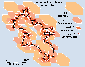
The use of hierarchical coordinate systems in geographic information systems
(GIS) is a relatively unexplored area, particularly with respect to cartographic
generalization techniques. This paper describes a hybrid geospatial data model
that enriches vector- topological descriptions of map features by quadtree encoding
of vertex locations. It also summarizes methods to encode, analyze, filter and
decode vector map data for display at scales smaller than those at which they
were captured. Geometric and combinatorial computations are performed either
on absolute quadtree addresses, on a world projection or directly on the sphere.
The software platform presently only processes one feature class at a time, but is
intended to handle more, whether stored as overlaid coverages or as independent
or linked objects. Map generalization computations are localized using hierarchical
hexagonal and triangular cells called Attractors. This "space-primary" approach
to map generalization does not depend upon a hierarchical feature classification
scheme, but the two perspectives are related and could be united. This paper
describes (1) the quaternary triangular mesh (QTM ) hierarchical location encoding
scheme; (2) modeling of cartographic features; (3) some new generalization
algorithms and conflict detection techniques; and (4) potential benefits of
applying this approach across feature classes.
Download the PDF version (291 kbytes)
![]()
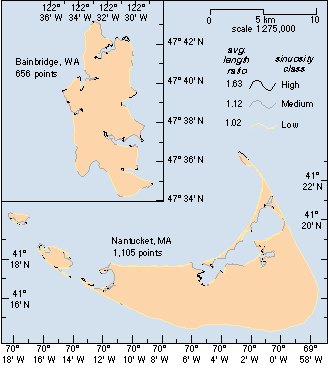
Scale, Sinuosity and Point Selection in Digital Line Generalization
NOTES

Author:    Geoffrey Dutton
Date:      January 1999
Type:      Journal article, draft version
Reference: Dutton, G. (1999). Scale, sinuosity and point selection in digital line
           generalization. Cartography and Geographic Information Science. 26(1), 33-53.

ABSTRACT
This paper examines some assumptions and results of cartographic line
simplification in the digital realm, focusing upon two major aspects of map
generalization , scale-specificity and the concept of characteristic points.
These are widely regarded as critical controls to generalization, but in our
estimation are rarely well-considered or properly applied. First, a look at
how scale and shape are treated in various research papers identifies some
important conceptual and methodological issues that either have been misconstrued
or inadequately treated. We then conduct an empirical analysis with a set of
line generalization experiments that control for resolution, detail and sinuosity
using four source datasets as examples (two island coastlines digitized at two
scales), resulting in about 100 different generalized versions of these figures.
These tests systematically explore consequences of linking scale with spatial
resolution and a variety of point selection strategies. Graphic results of this
exercise are displayed (at scale and enlarged) along with some basic statistics.
We feel that most of the common measures of generalization performance rely on
dubious assumptions about the value of fidelity of output to source, but at this
point we have no specific alternatives to propose in their stead. Rather than
proof, then, we offer evidence that whether our methods are used or others are,
sensitivity to scale and sinuosity can and must be built in to all digital map
generalization toolkits.
Download the main article, PDF version (318 kbytes) NOTE: Some figs are missaligned
Download 6 full-page figures, PDF version (1,510 kbytes)
![]()
A Hierarchical Coordinate System for Geoprocessing and Cartography (ch. 1)
NOTES

Author:    Geoffrey Dutton
Date:      October 1998
Type:      Ph.D. Dissertation Chapter 1
Reference: Dutton, G. (1999). A hierarchical coordinate system for geoprocessing and
           cartography. Lecture Notes in Earth Science 79. Berlin: Springer-Verlag.
           XIX + 231 pp. 97 figs., 12 plates, 16 tabs. ISSN 0930-0317; ISBN 3-540-64980-8

INTRODUCTION
When a mapping agency updates information on topographic maps or navigational
charts, usually more than one map is affected by a given change. Often, the
largest (most detailed) scale maps are edited first, and the changes then
transferred to the appropriate map at the next smaller scale, until either the
smallest scale is reached or the edited feature becomes too small to represent.
As a result of changes in the world -- or interpretations of it -- marks on maps
may change their shape or symbology, relative prominence, locations and labels,
according to organizational standards and procedures as well as expert judgement,
also known as "cartographic license." This tedious graphic editing process has
been described as "working through the scales," as it systematically propagates
edits from greater to less detailed cartographic representations. It is one
strategy of attacking problems in the art of map generalization, one which
specialists from many nations are struggling to understand, formalize and automate.

Until about a decade ago, map generalization was practiced almost exclusively
by trained cartographers, who learned it by tutelage, example and intuition,
deliberately, even rigorously, but not necessarily formally. Manual cartographic
generalization involves an unruly set of techniques and precepts that,
traditionally, were mainly practiced in public agencies and map publishing houses,
and each organization tended to have its own procedures, standards, guidelines
and aesthetics for compiling maps in fulfilment of its mission. Only recently has
this situation begun to change, but it has done so dramatically and definitively,
as maps -- along with every other form of human communication -- have become digital.
At the same time, the media, data, tools and enterprises involved in compiling and
communicating maps are rapidly becoming global. The author of this thesis, in
describing, demonstrating and assessing a specific digital approach to working
through scales, hopes to contribute to progress in both map generalization
specifically and spatial data handling generally.
Download the PDF version (67 kbytes)
![]()
The following four ascii coastline data files are available for download here in Arc/Info ungenerate format. Please refer to the metadata below regarding the contents of each file.
Bainbridge Island, Washington, USA, 1:250K --> download data (9 kbytes)
DATA: 1:250,000 NOAA/NOS digital nautical charts,
         vector coordinates in latitude and longitude
SOURCE: Coastline Extractor --
         http://crusty.er.usgs.gov/coast/getcoast.html
EXTENT: 122¤ 35' W - 122¤ 25' W (W-E);
         47¤ 34' N - 47¤ 43' N (S-N)
WIDTH: 8.62 km; HEIGHT: 16.58 km; AREA: 74.12
         km2
LENGTH: 72.13 km; POINTS: 433; AVG SEG LEN: 0.17
         km
PROJECTION: None (cordinates are longitude,
         latitude, in decimal degrees).
FORMAT: Arc/Info Ungenerate, ascii file, 433
         coordinates, 1 polygon
REMARKS: Data originally vectorized by NOS from
         digital radar imagery, conditioning unknown. Boundary
         segments have been concatenated to form polygons. The 1:250K
         scale specified for it implies a resolution between 100 and
         200 m (assuming a map resolution of 0.5 mm). As the average
         line segment length in the dataset is 200 m, this seems
         reasonable.
Bainbridge Island, Washington, USA, 1:80K --> download data (14 kbytes)
DATA: 1:80,000 NOAA/NOS digital nautical charts,
         vector coordinates in latitude and longitude
SOURCE: Coastline Extractor --
         http://crusty.er.usgs.gov/coast/getcoast.html
EXTENT: 122¤ 35' W - 122¤ 25' W (W-E);
         47¤ 34' N - 47¤ 43' N (S-N)
WIDTH: 8.59 km; HEIGHT: 16.41 km; AREA: 70.00
         km2
LENGTH: 77.42 km; POINTS: 656; AVG SEG LEN: 0.12
         km
PROJECTION: None (cordinates are longitude,
         latitude, in decimal degrees).
FORMAT: Arc/Info Ungenerate, ascii file, 656
         coordinates, 1 polygon
REMARKS: Data digitized from NOS charts at
         1:80,000, possibly with insets digitized from charts as
         large as 1:10,000, conditioning unknown. It is possible that
         that the area around Nantucket town harbor was digitized
         from an inset. The 1:80K scale implies a resolution between
         50 and 100 m (assuming a map resolution of 0.5 mm). As the
         average line segment length in the dataset is 120 m, this is
         not an unreasonable formulation.
![]()
Nantucket Island, Masssachusetts, USA, 1:250K --> download data (11 kbytes)
DATA: 1:250,000 NOAA/NOS digital nautical charts,
         vector coordinates in latitude and longitude (NOTE: only
         main island is included)
SOURCE: Coastline Extractor --
         http://crusty.er.usgs.gov/coast/getcoast.html
EXTENT: 70¤ 14' W - 69¤ 58' W (W-E);
         41¤ 14' N - 41¤ 23' N (S-N)
WIDTH: 22.00 km; HEIGHT: 17.50 km; AREA: 131.7
         km2
LENGTH: 102.5 km; POINTS: 525; AVG SEG LEN: 0.2
         km
PROJECTION: None (cordinates are longitude,
         latitude, in decimal degrees).
FORMAT: Arc/Info Ungenerate, ascii file, 525
         coordinates, 1 polygon
REMARKS: Data originally vectorized by NOS from
         digital radar imagery, conditioning unknown. Boundary
         segments have been concatenated to form polygons. The 1:250K
         scale specified for it implies a resolution between 100 and
         200 m (assuming a map resolution of 0.5 mm). As the average
         line segment length in the dataset is 200 m, this seems
         reasonable.
Nantucket Island, Masssachusetts, USA, 1:80K --> download data (14 kbytes)
DATA: 1:80,000 NOAA/NOS digital nautical charts,
         vector coordinates in latitude and longitude (NOTE: only
         main island is included)
SOURCE: Coastline Extractor --
         http://crusty.er.usgs.gov/coast/getcoast.html
EXTENT: 70¤ 14' W - 69¤ 58' W (W-E);
         41¤ 14' N - 41¤ 23' N (S-N)
WIDTH: 22.67 km; HEIGHT: 17.06 km; AREA: 119.9
         km2
LENGTH: 125.0 km; POINTS: 867; AVG SEG LEN: 0.14
         km
PROJECTION: None (cordinates are longitude,
         latitude, in decimal degrees).
FORMAT: Arc/Info Ungenerate, ascii file, 867
         coordinates, 1 polygon
REMARKS: Data digitized from NOS charts at
         1:80,000, possibly with insets digitized from charts as
         large as 1:10,000, conditioning unknown. It is possible that
         that the area around Nantucket town harbor was digitized
         from an inset. The 1:80K scale implies a resolution between
         50 and 100 m (assuming a map resolution of 0.5 mm). As the
         average line segment length in the dataset is 140 m, this is
         not an unreasonable formulation.
![]()